Jusr saw this. Pretty cool photo eh!

4 Likes


That was at les Eurokeennes music festival in Belfort (East of France)
2 Likes
Just something you may find interesting (if you didn’t already know of course). Out on my journey today I saw these cut into the stone kerbs on each side of the road:

It’s a ‘C’ with an arrow pointing towards the road
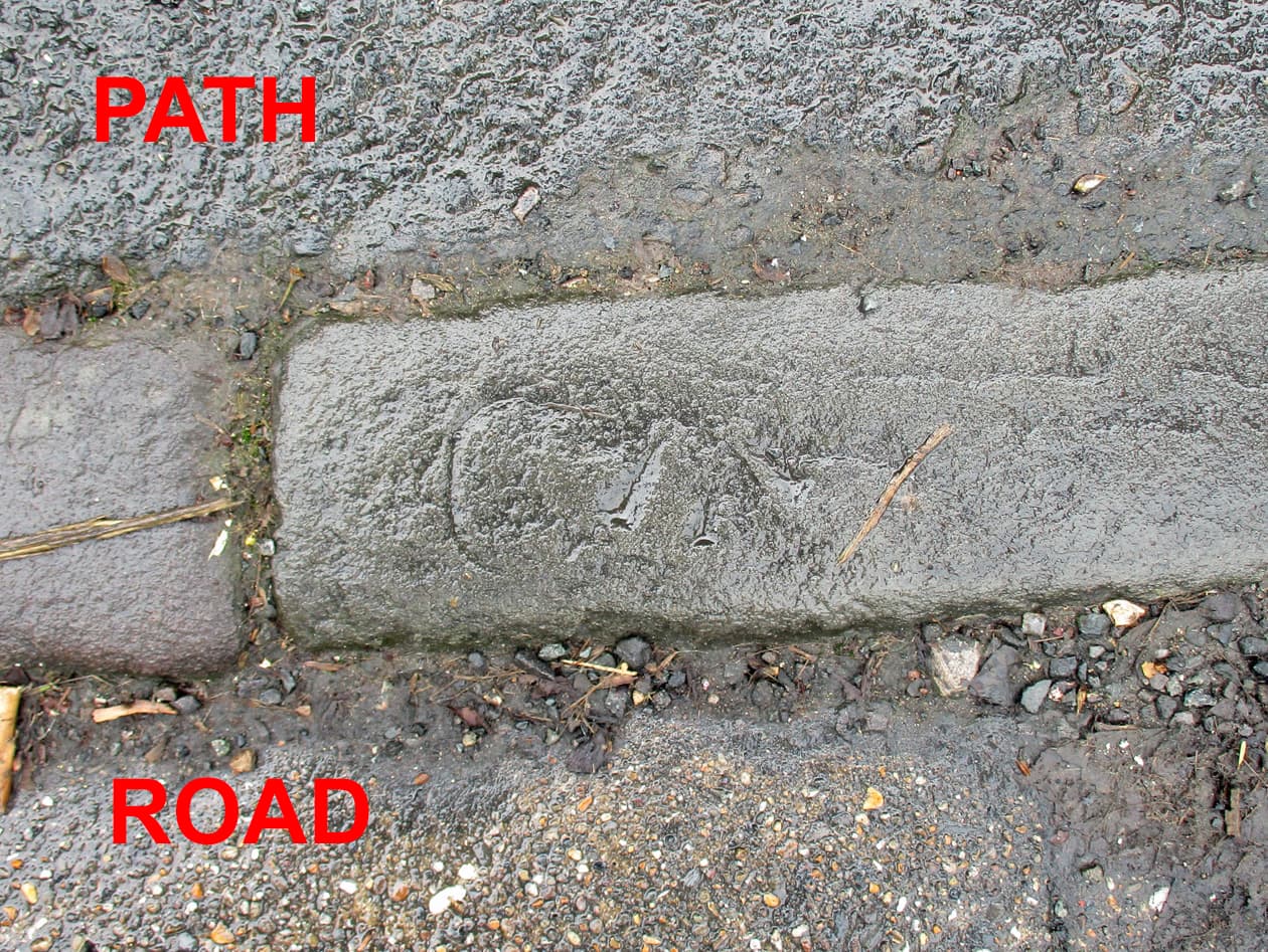
On the other side of the road is another ‘C’ with an arrow pointing towards the footpath. Both of the 'C’s arrows are pointing towards a Church which stands alongside the road.
These kerbstones have had a fair bit of work applied to carve the arrows and 'C’s in.

This is the corner of the church.
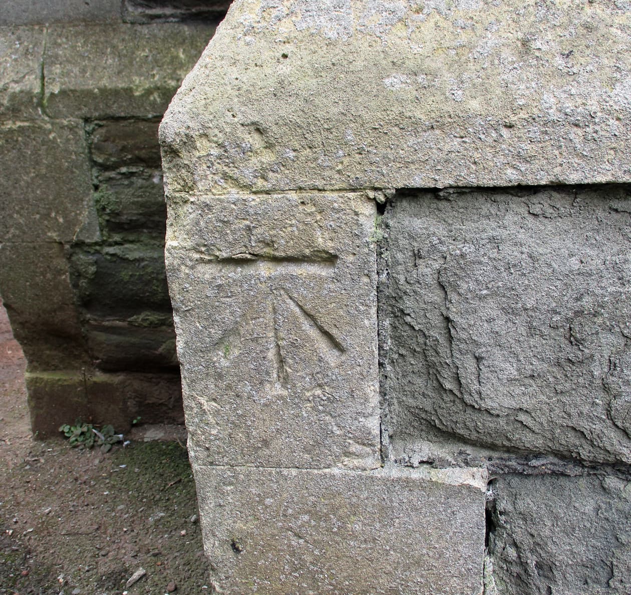
And here’s what the markings are indicating. A ‘Bench Mark’
In my younger days as a Civil Engineer these were found amongst the buildings in London. The arrow has a top line which has a known level above a datum. These ‘levels’ were known across the country and were regularly checked and updated. Engineering designs were completed with levels shown on drawings to allow construction to completed.
They are not required these days as setting out - level and theodolite work - is done by GPS and modern computer wizardry.
I can tell you, however, that getting the tunnel level and curves round a bend correct was a bit of a skill. Especially when those tunnel miners were waiting for their square marks as they were on bonus…
Have a look around when you are out walking. The bench marks are all over the country - normally on a corner of a good sized structure… ![]() over…
over…
12 Likes
Seen the bench marks and wondered what they meant, never seen the C though. Will have a look next time I pass a church ![]()
Is there nothing you don’t know about? ![]()
1 Like
In pompei the red light area was pointed out by cocks chiselled into the pavements. Handy
1 Like
Hillsborough, a town near me has an interesting stone sign, its miles to Dublin but its in Irish miles which are different to the miles we know. I didn’t know that.
4 Likes
I was going to say just that. It’s like having our very own Fred Dibnah.
1 Like
‘Handy’ was 10 denari, I believe.
1 Like
I just watched University Challenge - I got my usual two questions correct. ![]() I’m continually beaten by the Admin Staff but one day, one day…
I’m continually beaten by the Admin Staff but one day, one day…
2 Likes
My parents used to say “Emerson fittipaldi” on any questions they didn’t know.
I heard the name alot…
This was in the days of Emlyn Hughes and big bill as captains.
They were actually right once!
2 Likes
I celebrate if I get anything right on Only Connect ![]()
![]()
1 Like
Counterpoint on Radio 4.
1 Like
Brilliantly explained Iron.
These are all recorded by Ordnance survey and give accurate heights above sea level.
But the sea level constantly changes with the tides, so work that one out…!
Google is your friend…
From memory, Sea level is a mean average recorded over 7 years somewhere down south of UK.
6 Likes
I seem to remember there were two datums. The one that was used was Newlyn datum which, as you say, was the average sea level at Newlyn for several years prior to the First World War.
The company I worked for had a full set of ‘1250s’ for their area. 1250s were maps to a scale of 1:1250 that had all streets, buildings, ground levels etc marked.
When a design was undertaken for a construction project (a tunnel, shaft, pipeline etc) the surrounding area was surveyed. Accurate levels were taken across the area and related to the known benchmark levels. The marked bench mark levels on the drawings were checked with ordnance survey for the latest figures.
There were standard levels books which were filled in a certain way so anyone could pick them up and know what had been done. It was always a bit of a tense time when you were asked to take your survey books into the manager’s office. The way the books were completed showed errors in any setting out. Each type of construction project had it’s own tolerance requirements (written into contract documents) and you made sure that you was within those BEFORE you filled in your ‘good’ survey book.
Oh what fun…
7 Likes
This is probably a stupid question but how do you define the average sea level? (It always looked about the same when I was living thereabouts.)
2 Likes
I assume the low and high tide heights were measured (from some fixed point in Newlyn somewhere) over the several years around WW1. The average of all these heights was then calculated.
That height was then adopted as a datum level of 0.00 feet. Everything else in the country was then either above or below that datum level.
I expect there’ll be some line somewhere in Newlyn showing the zero level datum.
I suppose the datum will be some European agreed level these days.
Edit - I knew it, it’s here
8 Likes
My memory was almost correct.
A brilliant piece of history…!
Great link. Thanks.
4 Likes
Thanks @Iron , live all of 15 miles from Newlyn and didn’t know that was there.
Seems bizarre to use sea level as a datum when it’s constantly on a changing cycle (even ignoring rising sea levels due to climate change).
Living here the tide app is my go to on the smart phone and apart from the 50 minutes a day change in time, heights also change considerably. So we’re always checking so we know when that “secret” cove is accessible. Next Tuesday is on. ![]()
![]()


And of course every home near the coast needs one of these

6 Likes
That clocks not right, it’s stopped ! ![]()
1 Like